I am aware that people on trips with me have been concerned or lack confidence about how I am getting around without the use of the hallowed GPS. To start with I will not always be be exact in a path but sometimes more exact in a path than some GPS users. At times a I may point out a landmark to start a heading. Reasons may vary from or combination of.
- Destination is not visible.
- I remember that mark from approaching that area at another time maybe from a different angle. ( angle could mean a change of course later)
- It is a prominent mark easily identified to get us under way in the general direction.
- It may steer us away from a hazard that may lie close to the direct line.
- We may want to shave close to a Island as a point of refuge if needed in a long stretch.
Communication on the water with 3 or more skis is not suited to a full explanation of why and when’s. This leads to some confusion a times. I still feel that all should have an idea of direction (this may be a mistake ?).
Then there is the situation with GPS on board and the direct line is off and low fuel warning is happening. My seadoo does this with a third of a tank 50klms left. When we understand our skis consumption it is less alarming. When I have planned the trip and stated we should carry required + 20% or one fifth extra.
Being off line of route is not as costly in the total klms covered as one would imagine. To prove this on a scrape of paper draw a horizontal line 100mm long then mark half way and measure up 25mm with a dot join that dot to the ends of horizontal line. This represents your off route line will measure 110mm. Scale this to klms, at the center of your 100k journey you were 25ks off line but it only cost you 10ks at the end. This a drastic example but changes drastically on lesser margins that can occur. Should we be off line it needs to be away from hazards.
I hope the deviation point is understood that off the direct line a few hundred meters doesn’t matter to the end result as long as that few hundred meters doesn’t put us any closer to a hazard. Because I have been planning trip I may instinctively avoid the hazard without realising it myself.
The reason we go in group is to be there for one another. This idea that some riders get is I know the way home the GPS said so and they shoot off in a direction that is nearly out of sight and a different course is ridiculous. IF a mishap occurred no one else would know. This could be a communication problem to ?
Technology is great and can have a undeniable service but I want become a slave to it .
Route Plan
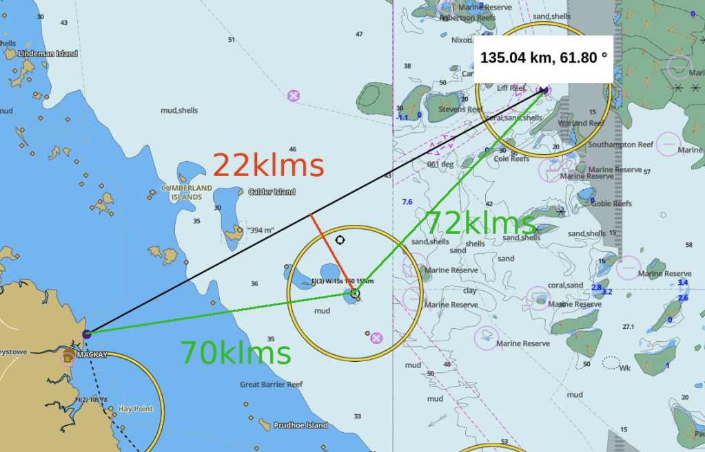
Using a desktop PC and this charts web site https://fishing-app.gpsnauticalcharts.com screen print area of trip planned and taking file to Office Works and get A4 colour prints laminated and carry them with me to fall back on. Starting off in baby steps say Keswick / St Bees 28ks off of Mackay and progressing through the local islands (Cumberland Group) learning the Islands, Bays, Distances and Hazards. Most days these islands are all visible and once familiar you will know say Wigton Island lays ENE of Cockermouth around 7ks. I am not sure that if I had a GPS from the beginning that I would know the Islands as well as I do now. Found myself concentrating on Islands and forgetting on getting back to harbour can be harder the mainland is there but where is the harbour. Returning to your point of departure can be challenging with out a GPS. One trick is to turn back and take in land marks and try to do this every 5 – 10ks on your way out. Seaforth, Victor Ck can be a bugger.
Planning a Reef run is out of the question nearly and not something I would try without a GPS. Simply because there is no visual islands to use as markers. Then I have to learn how to use it.
I hope some may get some good from this and as usual if any errors please let me know.
PS: let me say that because you were in a location GPS marked as way point in the past it may not mean it is safe to go directly to that point at another time ? If you don’t know why you need to find out.
